Hi , I'm using mapbox module to display locations taken from my datastore. When the record is selected the map is jumping to the right location but not displaying a marker.
Ideal I'd like a custom marker but anything at this stage will do! below is the array i'm passing in the point box
{{[
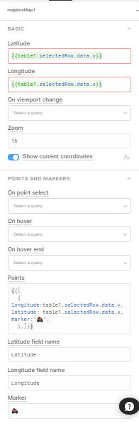
{ longitude:table1.selectedRow.data.y, latitude: table1.selectedRow.data.x, marker:" ",
",
},]}}
and for long/lat I've inserted {{table1.selectedRow.data.y}} for Lat and {{table1.selectedRow.data.x}} for long
Any help would be greatful.
Will
Hey @willfahy
Do you have a screenshot of that right hand panel with these values by chance?
1 Like
Using my laptop with low res so hopefully you can see that!
Will
no worries!
I bet that Retool thinks you are giving it a string as opposed to a number for the latitude and longitude inputs. You could try converting the latitude and longitude reference to a number maybe?
What do your table.selectedRow.data.x & y look like? Do you have anything in the GeoJson section of the map?
Also looks like there is an extra comma after the last latitude longitude point.
I haven't touched the GeoJson section still have the default information in it.
I removed the extra commas and the map is still working.
The x & y data is for example : 53.275705 and -7.491993
Will